Zion National Park is one of the best and busiest parks in the United States. Located in Southern Utah, this is our favorite region to explore some of the best US national parks, including Zion, Bryce Canyon, the Grand Canyon, Vermillion Cliffs National Monument, and the Grand Escalante Staircase.
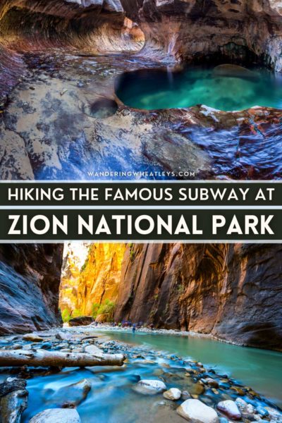
Zion has three famous hikes (aka the “Big 3”) that are some of the best in the country. These hikes are Angel’s Landing, the Narrows, and the Subway hike. The Zion Subway hike is an incredible hike that is often a favorite at Zion, in particular with photographers.
There are two ways to tackle the Subway Zion hike – “top-down” or “bottom-up.” These require different gear and different skill sets. Read on to learn everything you’ll need to know to prepare for your Zion adventure!
Don’t forget to check out our web story: The Subway Zion National Park Hiking Guide
Content and photographs provided by Yana Kogan and Timon.
Disclaimer: This post may contain affiliate links. If you make a purchase or booking through one of our links we may earn a small commission (don’t worry, it’s at no extra cost to you).
The Subway Zion National Park Hiking Guide
Subway Hike Top-Down Route
The “top-down” trail into the Subway is an exciting way to do this hike. This route involves proper canyoneering and the only way into the tunnel is by rappelling into the canyon. Knowledge of rappelling, having the proper equipment and knowing all safety measures are important for at least one member of the group.
A Zion wilderness permit is required and there are a limited amount of permits allocated each day. It’s a lottery process and you can get more information and enter it on the Zion Wilderness Reservations page.
This route into the tunnel also requires some swimming. There are dozens of canyoneering companies where you can rent gear and get helpful information about the hike. Unfortunately, commercial guides are not allowed in the park so you’ll have to do this one on your own. And it’s worth asking about a shuttle service as the hike starts and ends at different trailheads.
Subway Hike Bottom-Up Route
The “bottom-up” route from the Left Fork Trailhead does not need any technical climbing skills. Aside from the original descent to the riverbed, the trail is relatively flat. This trail requires maneuvering through the river bed and ends at the tunnel. Depending on water levels, sections of the river can be ankle-deep to knee-deep.
Best Time to Visit Zion
Zion is open year-round but during the peak summer months, the park is extremely busy. The popular hikes now have a lottery permit system because they were overrun with tourists.
We recommend visiting during the spring and fall. If there is little snowfall, the winter is also an excellent time to visit Zion as you’ll find much fewer crowds. During the winter the trails can be icy, so best to plan your trip between September and November.
Where to Stay When Visiting Zion
There are limited options for accommodation close to the Zion park entrance. If you want to stay nearby, it is advised to make a booking far in advance. Keep in mind that hotels are pretty pricy if you want to stay near the park.
An alternative is to stay in Hurrican, Utah, or Kanab, Utah, both a 35-minute drive from park entrances.
Guided Canyoneering Tours
Dozens of canyoneering tour companies offer guided walks near Zion; however, guided canyoneering is prohibited within Zion National Park. If you would like to join a guided tour, there are excellent canyoneering trips in the area, but the Subway hike cannot be one of them.
To rent gear, we recommend the gear shop at Zion Rock Guides.
Permits for the Subway Zion Hike
This hike requires a permit for both directions into the Subway. Online reservations for most canyons in Zion are available during a two-month time frame, one month in advance. Once that is filled up, there is a last-minute drawing 2-7 days in advance. In the unlikely event that there are leftover permits, walk-in permits are available at the visitor center one day before the trip date.
Because we went during the winter, we were able to get permits on the same day. Ask the Rangers for up-to-date information on the hike, the water level, and for any tips based on current conditions. Permits cost an extra fee in addition to the National Park fee.
How to Get to the Subway Zion Hike
Bottom-Up: The trail starts from the Left Fork Trailhead, 10 miles from the visitor center.
Top-Down: The trail starts from Wildcat Canyon Trailhead.
Hiking The Subway Trail Bottom-Up
Subway Hike Details
Distance: 11.0 Miles (17.8 km)
Elevation Gain: 1,450 feet (442 m)
Time: 5 hours 24 minutes
Difficulty: Moderate
The Subway Hike: Beginning
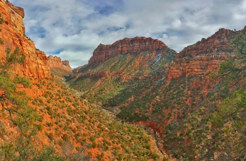
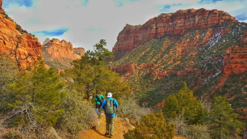
The beginning of the bottom-up hike is flat and can get muddy. There are excellent viewpoints of the canyon and down to the river. After the flat section, the trail steeply descends into the canyon. The descent is roughly 1,000 feet, all the way down to the river.
Subway Hike: Riverbed Section
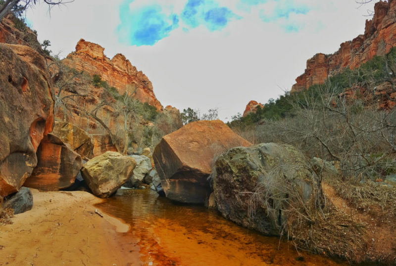
Once at the riverbed, the trail will stay along the river the rest of the way. Cross the river several times to continue on the trail. For several miles, the trail continues to snake along the river, with small boulders here and there.
Subway Hike: Cascading Falls Section
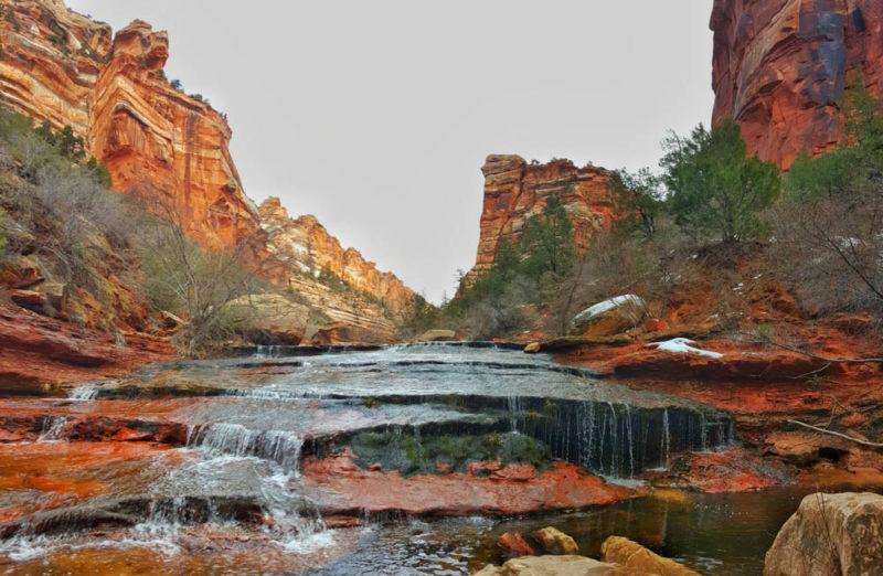
The landscape and the river both change the last mile before arriving at the Subway. There are several cascading waterfalls and this section of the hike is very slippery. Try to avoid the slippery dark green moss on the rocks. During this stretch, there are sections where waterproof boots would come in handy as the water can get 1 -3 inches deep.
The best places to cross the river are typically right at the edge/top of the cascading waterfalls.
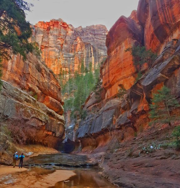
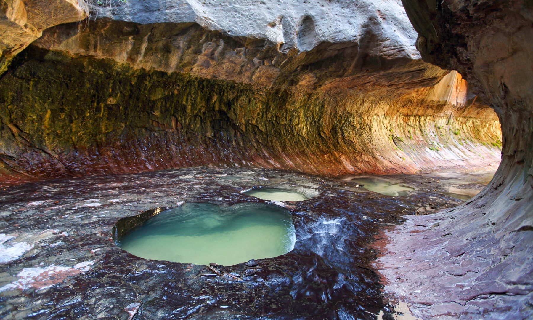
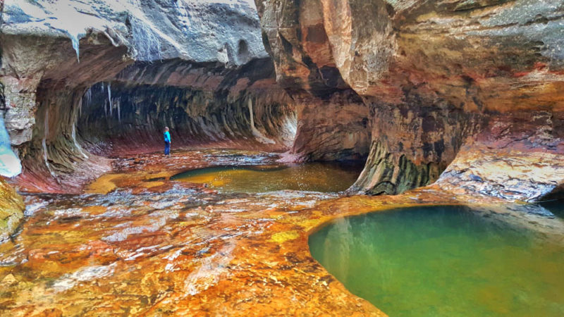
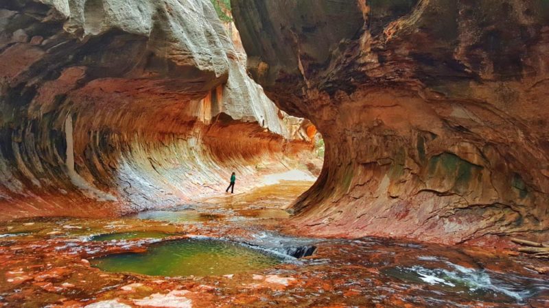
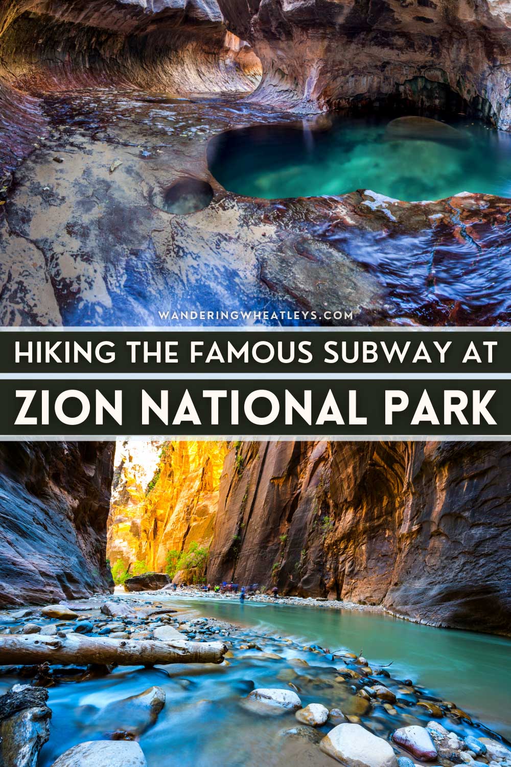
Subway Hike: The Tunnel Section
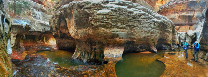
After several small waterfalls, the trail flattens and in the distance, the canyon walls begin to close in. At the bottom of the canyon, the Subway is formed. The entrance is grand and obvious, and the reason you came for this hike.
Continue into the Subway which snakes to the left. Be careful while walking through the Subway, as there are several deep pools. At the end of the tunnel, there is a large pool that is quite deep and it would require some climbing, potentially with rope, to go any further. This is where you can turn around and enjoy the scenery!
The hike is an in-and-out hike, so return using the same route you came in.
What to Bring on the Zion Subway Hike
- Permits
- Hiking shoes (waterproof recommended)
- Trekking poles
- Extra socks
- Sunblock
- Water
- Snacks
- Bathing suit (if you plan to swim in one of the swimming holes)
- Light waterproof jacket
- Pack rain cover
- Dry bag
That’s it – we hope you have a wonderful time hiking around Zion National Park!
Planning a trip to Utah? Check out our favorite books and travel guides!
SHARE THIS ON PINTEREST


I am looking for how to get to the trailhead! I know the shuttles don’t go that direction, so how did you get there? Bottoms Up is our planned route.